
Quote
JoelTDahl
Can't really report on the condition of the road, except for the portion from Mono campground to the springs themselves, because rather than driving the road in, I hiked in via this route.
As for the portion of the road I can report on, it seems in good condition for a really narrow dirt road with lots of potholes and bumps. I think it is theoretically possible to do it in a low-clearance vehicle, but it would be a very nerve-wracking and slow drive. I'm just as glad I hiked in rather than tried to drive in. I met a few bikers who came in via the road the whole way and they said that the portion I saw was pretty much like the rest of it.
Update on the road report: today, I attempted to go to Big Caliente Hot Springs.
Suffice it to say, I strongly recommend against trying to drive even to Big Caliente Hot Springs, much less all the way to Little Caliente, unless you're in a Jeep/Pickup.
I took one look at the dirt road at the part where the pavement ends on East Camino Cielo, and decided to park and attempt a hike in along the road. I noticed that the road has several severe wash-out spots that have got to be really treacherous in a regular sedan. One or two of them might be a little nerve-wracking even in a high-clearance vehicle.
That said, I was passed on my hike by a few regular sedans driving the road. I don't know how they made it past those washed-out spots, but apparently they did. Perhaps I'm overly risk-averse, or perhaps those people were total fools. Maybe a little bit of both.
I didn't actually make it all the way to Big Caliente, because I'd been planning on driving it, so I got a leisurely (read: late) start in driving up to Santa Barbara from L.A., so I didn't start hiking the road until 2pm. I made it all the way to the river crossing over the Santa Ynez river (over the concrete dam -- water was only an inch or two deep -- I didn't even take my boots off) by 4pm, and then decided that I didn't have enough daylight left to make it to the springs (still about 4 miles away, according to my GPS) and still make it out before dark, so I turned back from there.
I'm thinking the next time I try to make it to Big Caliente, I'll plan on a full-day hike, and go by a more direct route. Hoping people can give me some advice.
Based on looking at topo.com, I think I want to park at the same place I did today (by the water tank at the end of the paved portion of the road), and then
1) Hike down the dirt road about a half-mile to where the Romero Trail crosses the road (I passed the trailhead -- marked as Romero trail by a sign post -- today while walking the road), and then turn left onto the Romero Trail, heading down into Blue Canyon.
2) Hike the Romero Trail down into the canyon, until it joins the Blue Canyon Trail.
3) Turn left onto the Blue Canyon Trail, follow it until the trail junction by Cottam Camp. Take the right fork at the trail junction (not sure what trail this is now).
4) Follow the trail, crossing the Santa Ynez River, until it hits Camuesa Road.
5) Hang a right on Camuesa Road.
6) Here's where I'm not sure (because Big Caliente isn't marked on the map): To get to Big Caliente Hot Springs from here, do I follow the road until I
6a) Follow the jeep trail that goes up the top of the ridge that's just to the right of Horse Canyon
or
6b) Follow the road up Agua Caliente Canyon (from the junction near the Pendola Guard Station) to Agua Caliente Spring, and eventually on to Big Caliente?
or
6c) Neither of the above (in which case, where do I go once I hit Camuesa Rd?).
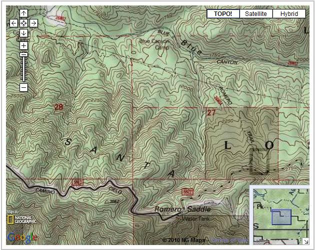
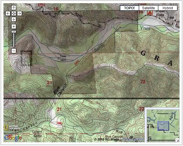
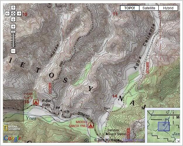
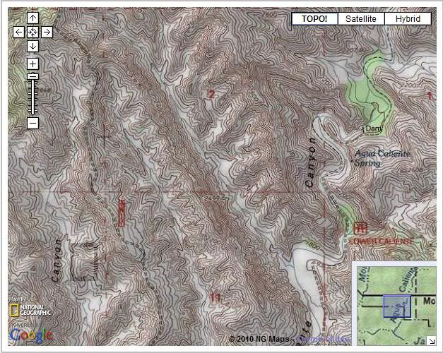
Screenshots from topo.com:
Steps 1-3:
Steps 4-5:
Steps 6a/6b/6c:
Presumably after step 6 (this is scrolling north, following the two roads I mention in step 6):
Appreciate whatever advice anyone can offer!
Joel
Edited 1 time(s). Last edit at 05/04/2010 06:58AM by JoelTDahl.


