All posts are those of the individual authors and the owner of this site does not endorse them. Content should be considered opinion and not fact until verified independently.

January 05, 2012 01:38PM
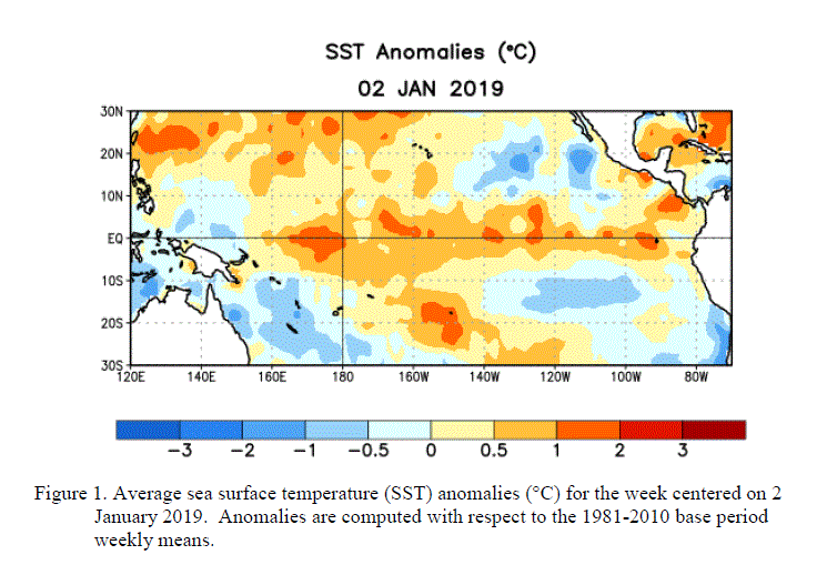
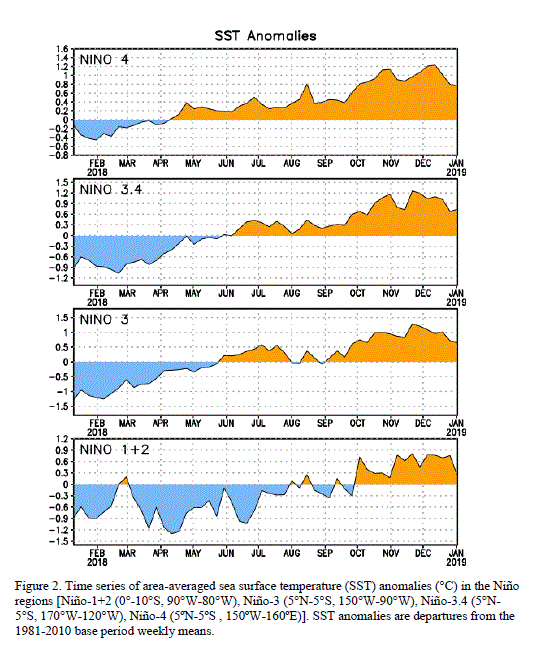
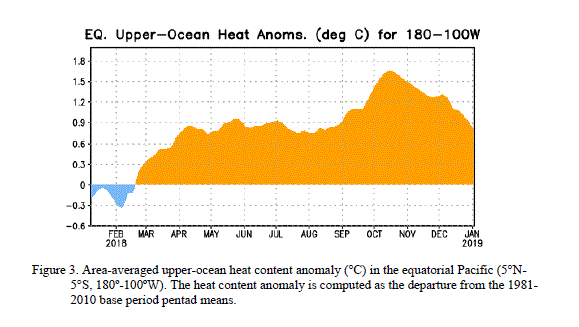
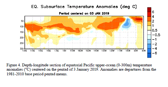
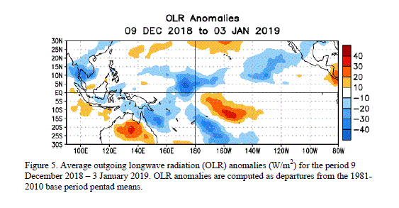
During December 2011, below-average sea surface temperatures (SST) associated with La Niña continued across the eastern and central equatorial Pacific Ocean (Fig. 1). The weekly SST index in the Niño-3.4 region remained near -1.0oC throughout the month (Fig. 2), indicating a weak to moderate La Niña. The oceanic heat content (average temperature in the upper 300m of the ocean) anomalies strengthened across the eastern Pacific (Fig. 3), reflecting a large area of below-average temperatures in the subsurface (Fig. 4). In the atmosphere, anomalous low-level easterly and upper-level westerly winds strengthened over the central and west-central Pacific. Convection remained suppressed in the western and central Pacific and enhanced over northern Australia and parts of Indonesia and the Philippine Islands (Fig. 5). Consistent with these conditions, the Southern Oscillation Index (SOI) also strengthened. This evolution is consistent with past events, in which the atmospheric components of La Niña become strongest and most well-defined during the Northern Hemisphere winter. Collectively, the ongoing oceanic and atmospheric patterns reflect the continuation of a weak to moderate La Niña.

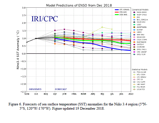
A majority of models predict a weak or moderate strength La Niña to peak during the December – February season, and then to continue into early Northern Hemisphere spring season before dissipating during the March to May period (Fig. 6). A slight majority of models predict La Niña to remain weak (3-month average SST anomaly in the Niño-3.4 region between -0.5 and -0.9oC) this winter, while several others predict a moderate-strength episode (anomaly in the Niño-3.4 region between -1.0 and -1.4oC). The latest observations, combined with model forecasts, suggest that La Niña will be of weak-to-moderate strength this winter, and will continue thereafter as a weak event until it likely dissipates sometime between March and May.

During January - March 2012, there is an increased chance of above-average temperatures across the south-central and southeastern U.S., and below-average temperatures over the western and the northwest-central U.S. Also, above-average precipitation is favored across most of the northern tier of states and in the Ohio and Tennessee Valleys, and drier-than-average conditions are more likely across the southern tier of the U.S. (see 3-month seasonal outlook released on 15 December 2011).

SubjectAuthorViewsPosted

El Niño/Southern Oscillation (ENSO) Diagnostic Discussion

Rick1574January 05, 2012 01:38PM

Re: El Niño/Southern Oscillation (ENSO) Diagnostic Discussion

mdskibum1346January 05, 2012 05:03PM


Sorry, only registered users may post in this forum.

Click here to login