DIAGNOSTIC DISCUSSION
issued by CLIMATE PREDICTION CENTER/NCEP
8 December 2011
ENSO Alert System Status: La Niña Advisory
Synopsis: La Niña is expected to continue through the Northern Hemisphere winter 2011-12.
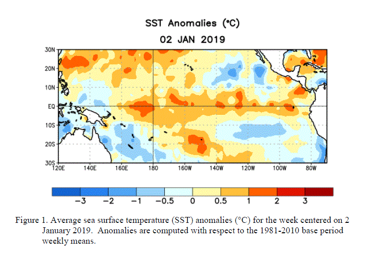
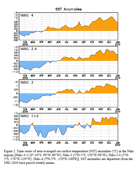
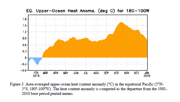
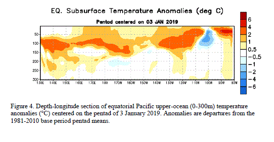
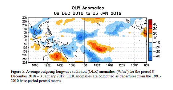
During November 2011, below-average sea surface temperatures (SST) associated with La Niña conditions continued across the eastern and central equatorial Pacific Ocean (Fig. 1). The recent weekly SST indices in the Niño-3.4 and Niño-3 regions maintained levels near -1.0oC (Fig. 2), indicative of weak to moderate La Niña. The oceanic heat content (average temperature in the upper 300m of the ocean, Fig. 3) weakened slightly, but still indicates a large area of below-average temperatures at depth in the eastern Pacific (Fig. 4). Also reflecting La Niña, the atmospheric circulation over the global tropics featured anomalous low-level easterly and upper-level westerly winds in the central and west-central Pacific. Averaged over the month, convection was suppressed near and just west of the Date Line and enhanced over northern Australia and parts of Indonesia (Fig. 5). Collectively, these oceanic and atmospheric patterns are consistent with the continuation of La Niña conditions.
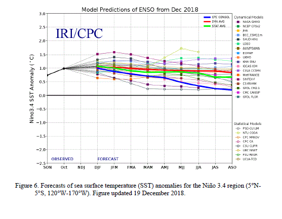
A majority of the models predict a weak or moderate strength La Niña to continue through the Northern Hemisphere winter (Fig. 6) and then gradually weaken after peaking during the December – January period. The models are roughly split between those that predict La Niña to remain weak (3-month average in the Niño-3.4 region between -0.5 and -0.9oC) and those that predict a stronger episode. Over the last half-century, La Niña events that were preceded by ENSO-neutral conditions during the Northern Hemisphere summer (May-August) were less likely to attain strong amplitude (stronger than –1.5oC) the following winter. This observation, in combination with the model forecasts, favors a weak-to-moderate strength La Niña during the Northern Hemisphere winter, likely weakening with the onset of northern spring.
During December 2011 - February 2012, there is an increased chance of above-average temperatures across the south-central and southeastern U.S. below-average temperatures over the western and north-central U.S. Also, above-average precipitation is favored across the northern tier of states, excluding New England, and drier-than-average conditions are more likely across the southern tier of the U.S. (see 3-month seasonal outlook released on 17 November 2011).
This discussion is a consolidated effort of the National Oceanic and Atmospheric Administration (NOAA), NOAA's National Weather Service, and their funded institutions. Oceanic and atmospheric conditions are updated weekly on the Climate Prediction Center web site (El Niño/La Niña Current Conditions and Expert Discussions). Forecasts for the evolution of El Niño/La Niña are updated monthly in the Forecast Forum section of CPC's Climate Diagnostics Bulletin. The next ENSO Diagnostics Discussion is scheduled for 5 January 2012. To receive an e-mail notification when the monthly ENSO Diagnostic Discussions are released, please send an e-mail message to: ncep.list.enso-update@noaa.gov.
